
Coastal Marine Biodiversity
The coastal biodiversity program provides information and advice for the management of local fisheries, aquaculture, and marine protected areas. The program also contributes to Canada’s commitments to the United Nations Convention on Biological Diversity.
Human activities and broad changes in coastal climate may alter the marine ecosystem through species distribution (locations), composition (number and types), and productivity. These changes may also result in changes in the number of abundant or rare species as well as the introduction of non-native (invasive) species that could alter the natural balance between species and habitat.
Biodiversity scientists use different methods to monitor and identify changes in species diversity (variety) and distribution in the coastal zone. Biodiversity indicators, such as:
- number of species;
- proportions of species both dominant and rare; and
- the amount of area sampled to observe these species establish reference points for current conditions.
Baseline Monitoring:
Baseline monitoring establishes a measure of species presence and changes over time. Reliable monitoring requires standard sampling methods with an understanding of how species change over time and area. Frequent multi-species surveys are important to establish a baseline of information.
 Baseline monitoring also relies on a broad network of expertise and efforts to gather and share information on different species types, habitats, and areas. Our researchers work in collaboration with other government and non-government programs that regularly collect and assess biodiversity and habitat information within Canada’s coastal zone and worldwide.
Research to improve biodiversity monitoring evaluates existing programs and their areas under study, and explores new activities to improve this network with respect to distribution, time, and species groups.
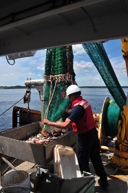
A trawl net is one of many effective methods to capture a diversity of species in the coastal zone. Samples taken from this net are identified and counted, along with a record of position, depth, and water temperature to compare changes in species composition over time and area.
Habitat Mapping:
Accurate measurement of habitat characteristics, such as bottom substrate (material), vegetation, and physical water parameters (temperature, salinity, turbidity) are essential to understanding species presence within an area and the role of habitat for diversity. Habitat mapping is done in a careful and consistent manner to accurately record underwater habitat features over large areas. Station scientists employ scuba diving survey methods, submersible cameras, remote sensors, and multi-beam technologies to measure the diversity of underwater habitats in the coastal zone.
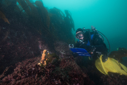 A DFO-Science diver conducting underwater habitat mapping at Brier Island, Nova Scotia. The diver records habitat characteristics, such as substrate and slope, as well as all species encountered during the survey. Automatic measurements of depth, temperature, salinity, and turbidity are recorded using automatic oceanographic sensors attached to the diver. Both a photographic record and biological specimens are collected to help identify the many different species observed during the dive.
Taxonomy:
The identification and naming of native, invasive, and new species requires expertise and expert products in taxonomy (classification). Taxonomic accuracy is essential for species-based research and management programs. Sampling over large geographic areas and long time scales requires up-to-date and efficient methods for species identification. Scientists work in collaboration with research and education institutions, including museums and taxonomic service providers such as the Atlantic Reference Centre to develop expertise, training, and resource materials for species identification. Taxonomy products include:
- improved field identification keys;
- taxonomic reviews and revisions;
- new species identification and;
- new species distributions materials.
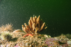 Many species are captured during sampling. A complete and accurate record of all species and their abundance is needed to record changes in biodiversity over time and area. Training in species identification and good sources of literature are essential to this work.